


By James M. Arnold, Weather Specialist
Photo/Sue Wambolt
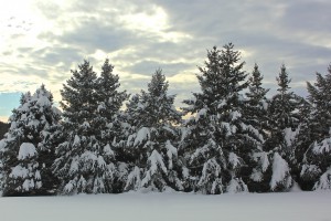
Region – The Blizzard of 2015 turned out to be everything it was advertised to be. Massachusetts was ground zero for what were in some cases record shattering amounts of snow, particularly in Worcester and Middlesex counties. Here is a link to the National Weather Service snowfall total page, and you will be amazed at the number of communities that measured 30 inches or more.
This storm turned snow deficits most communities were reporting so far this winter into surpluses and in some cases pretty large surpluses. But as they say, that was yesterday and yesterday’s gone.
Looking ahead, clearing and cold weather will be our lot today followed by a very cold night tonight with temperatures sinking to zero or below in the coldest areas. Thursday will be pretty tranquil with increasing clouds throughout the day before our next chance for snow Thursday night and Friday. A clipper system will be diving out of southern Canada, through the Great Lakes region and across New England. I expect it to go to our north off the coast into the Gulf of Maine and intensify over the ocean. If so, we can expect a period of occasional light snow later Thursday night and Friday leaving us with about 1 to 3 inches. Daytime temperatures will be in the low to perhaps mid 30s, allowing for at least some melting. Another very cold air mass will follow in the wake of the storm and by Saturday morning temperatures will return to near zero levels. Saturday night will be very cold with good radiational cooling sending temperatures as low as -5 to -10 in the coldest spots. Sunday we turn our attention to yet another stormy period, as a system approaching from the southeast and another from the Great Lakes approach our region. This looks to be a messy storm as temperatures will once again be in the 30s. Thereafter it will likely get very cold, with temperatures falling to a bit below zero for the next two or three nights. Yet another and likely more significant storm will threaten our region later next week.
Unless the Friday storm becomes more of a threat to us, this is the last mention of it here. I will monitor the Sunday night system and will update that one if needed.
James M. Arnold is a Weather Specialist working with Shrewsbury Emergency Management Agency; town of Princeton; Worcester Emergency Communications and Emergency Management Agency; Southborough Emergency Management Agency; town of Grafton and Wachusett Mountain Ski Area


