


By James M. Arnold, Weather Specialist
 Region – After a very cold morning where the temperature reached a low of -12.8 degrees at my home, temperatures have moderated a bit and light snow has begun. Over the last hour or so, radar returns indicate precipitation filling in and becoming a bit banded at this early time. I have no overall changes to the outlook from several days ago and the storm is about to begin to redevelop off the southern New Jersey coast, though this location is just a bit more to the south than I had thought earlier. Whether this plays any part in what our weather is remains to be seen. Snow will continue at varying rates throughout the afternoon and evening before it picks up in intensity around midnight as the surface system explosively intensifies (undergoing “Bombogenesis) just east of the Cape. As this happens, snow will again become moderate to occasionally heavy. It will not fall nearly as heavily as we have seen in some of our recent storms, but over a period of time a lot can still accumulate. The wind will pick up from the north and northeast eventually reaching speeds of 20 to 30 mph with gusts to near 55 mph here in the Shrewsbury area; 25 to 35 mph with gusts to near 65 mph along the coast and 35 to 45 mph with gusts approaching 80 mph over the Cape and Islands around dawn tomorrow. Blowing and drifting will cause whiteout/blizzard conditions at times, adding to the travel difficulties during this storm. This will continue throughout much of the morning before tapering off and ending from west to east during tomorrow afternoon. Severely low wind chill values will be common throughout the region.
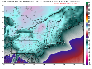
Clearing will follow later in the afternoon and winds will shift to the northwest and subside only a bit, still gusting to 50 mph during tomorrow afternoon and night. Temperatures will fall from already low levels during Sunday afternoon reaching near zero degrees in the late afternoon and continuing to fall during the night, and most areas could be substantially below zero by Monday morning. Severely cold wind chills will continue well into Monday morning and as the wind relaxes a bit during the afternoon wind chill conditions will moderate as well. Monday night could be the coldest of the stretch and the coldest seen for several years should clouds from the next system hold off and allow radiational cooling to set in, with the coldest spots approaching 20 degrees below zero. Temperatures will slowly moderate Tuesday, as the next of our seemingly endless series of storms approaches.
There are still no substantive changes to my accumulation outlook as I am still am looking for a snowfall total of from 6 to 8 inches in our western and northern areas to as much as 10 to 12 inches near the Route 495 corridor, (where it can be measured). In and around Shrewsbury I expect 8 to 10 inches of heavily drifted snow to fall. As noted, the wind will be quite strong throughout most of the storm and for a day or so afterwards, with a lot of blowing and drifting, particularly in the usual susceptible areas.
This will be the last statement regarding this storm. I am going to pause and catch my breath before beginning to think about the next storm coming our way about Tuesday.
James M. Arnold is a Weather Specialist working with Shrewsbury Emergency Management Agency; town of Princeton; Worcester Emergency Communications and Emergency Management Agency; Southborough Emergency Management Agency; town of Grafton and Wachusett Mountain Ski Area


