


By James M. Arnold, Weather Specialist
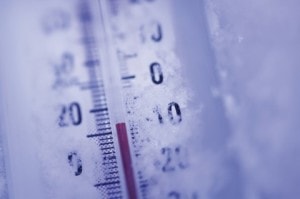
Region – Despite the temperature falling to -2° this morning which is the coldest I have seen so far this winter at my home, that is nothing compared to what is in store for us this weekend. Today will be a pretty nice mid-winters day here in central Massachusetts while clouds will be on the increase over coastal regions, the Cape and Islands in response to an ocean storm passing well out to sea. Those locations could see accumulating snow beginning later tonight and continuing off and on into Saturday morning with 2 to 5 inches expected from a combination of the storm and ocean effect flurries. For the rest of us, the main weather event will be the brutally cold conditions moving in early tomorrow (Saturday) morning. The arctic front will cross our region during the early morning hours and be followed by gale force northwest winds which will usher in our extremely cold conditions. Temperatures will fall during the day reaching 0° by nightfall and dropping to -10° to -15° by Sunday morning. Coupled with strong to gale force northwest winds, our area will see wind chill values drop to -35° or lower during periods of stronger winds. These are dangerously cold conditions, threatening both life and property if precautions are not taken. Exposed skin can freeze in a matter of minutes and underlying flesh can freeze soon afterwards. Precautions need to be taken to prevent susceptible pipes from freezing which could lead to structure damage from flooding. Here is a link to the National Weather Service where much cold weather information is available:
Here is a link to the Massachusetts Emergency Management Agency cold weather resources page:
http://www.mass.gov/eopss/agencies/mema/
Use extreme care when using any supplemental/alternative heating devices should power go out or your primary heat source proves to be insufficient.
With light winds, the usual cold spots around central Massachusetts could reach values of -10° to -18° early Monday morning, but temperatures will moderate during the day. Clouds will be on the increase and we will be faced with a wide range of winter precipitation types late Monday night and Tuesday, but it should all end up as plain rain late Tuesday after beginning as a brief period of snow, changing to freezing rain then rain. More on that later.
James M. Arnold is a Weather Specialist working with Shrewsbury Emergency Management Agency; town of Princeton; Worcester Emergency Communications and Emergency Management Agency; Southborough Emergency Management Agency; town of Grafton and Wachusett Mountain Ski Area


