


By James M. Arnold, Weather Specialist
 Region – Here we go with storm number 3 in our current series bearing down on us. I don’t know what is it about March 13th, but 25 years ago on March 13th, the “Storm of the Century” raked the east coast from Florida to the Canadian Maritimes. I remember it well as that was my daughter and son-in-law’s wedding day! The great “Blizzard of 1888” struck the northeast from March 11th through the 14th, dropping prodigious amounts of snow. And now we await the storm of March 13, 2018, which could rank right up there when it is all said and done, as it will intensify explosively perhaps reaching “bombogenesis” status! This event will produce blizzard conditions with very heavy snow, high winds, coastal flooding, beach erosion and make travel tomorrow and perhaps also Wednesday morning nearly impossible. Thundersnow is also quite likely across the southeastern portion of southern New England.
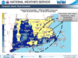
Clouds are thickening this afternoon and will become a solid overcast by evening. Light snow will begin near or a bit before midnight and become moderate to heavy through the early morning hours and will begin to be blown around by an increasing northeast wind. Snow will fall all day at a moderate to heavy rate at times before tapering off and ending Tuesday evening. Some occasional light snow or flurries are likely through Wednesday morning. This looks to be a snow event for all of southern New England, as the coastal plain, Cape Cod and the Islands will not escape the heavy snow. As far as accumulations that are expected, a general 12 to 20 inch accumulation seems likely across all of southern New England. There will be a few isolated reports of up to 25 inches primarily on the east slopes of the Worcester hills where additional lift is found and likely the Plymouth County area should the coastal front set up there. The cleanup will be helped by breezy and cold weather for Wednesday afternoon and Thursday, followed by quiet and warmer weather through next weekend.
Winds over central Massachusetts will increase to 20 to 30 mph with some gusts to 45 mph. The closer to the coast the higher the wind will be, as inside the Route 128 corridor winds will be 30 to 40 mph gusting to 55 mph at times. Right along the coast, Cape Cod and the Islands winds could reach 40 to 50 mph sustained for short periods of time and gust past 80 mph on the outer Cape and Nantucket. Over most of New England the snow will be drier and fluffier than the past two storms, which will significantly reduce the threat of widespread tree damage and subsequent power outages. The exception to this will be the areas along the immediate coast, Cape Cod and the Islands. There, snow will be a bit stickier and will pose a greater threat of plastering trees, poles and wires and causing damage.
Along the coast tides will not be unusually high, which will help to keep tidal flooding down. Still, with the likelihood of hurricane force gusts there will be some flooding in susceptible areas, particularly those areas where protective structures and/or dunes have been weakened or damaged by previous storms . In addition, large and battering waves will cause additional major beach erosion along east facing beaches.
James M. Arnold is a retired Weather Specialist who has worked with Shrewsbury Emergency Management Agency; town of Princeton; Worcester Emergency Communications and Emergency Management Agency; Southborough Emergency Management Agency; town of Grafton and Wachusett Mountain Ski Area


