


 By James M. Arnold, Weather Specialist
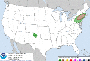
The Storm Prediction Center has upped the ante as far as the possibility of a tornado or two somewhere in Southern New England this afternoon. They now show a 5 percent chance of a tornado in western and central Massachusetts as far east as about the Route 495 corridor and a 2 percent chance of a tornado for much of the rest of the state, with the exception of those areas east of a line from about Boston to Providence. A large portion of neighboring Rhode Island, Connecticut and New York and also within these areas. Please see the SPC forecast map showing the likelihood and areas potentially impacted, which to the side.
As the air mass continues to destabilize with increasing sunshine and rising temperatures later this morning and the first part of this afternoon, thunderstorm activity will begin to move into our area during the mid to late afternoon. Not everyone will see thunderstorm activity but most of the area likely will. Some of these will likely reach severe limits with strong to damaging wind and hail in some areas. With a moist air mass in place heavy rain is also likely in some locations which could lead to isolated urban and street flooding. In addition, it is possible that one or two of these severe storms could spin up a brief tornado as well. As the National Weather Service said this morning in their forecast discussion, this is a day to really be “weather aware”.
These storms will move away later this evening and be followed by much cooler air for Wednesday, under partly cloudy skies. Temperatures tomorrow will struggle to reach the mid 60s, but warmer conditions will return for Thursday as temperatures rebound to 80° to 85°. A potentially heavy rain event for Friday night and Saturday will move in, and this has a tropical connection so plentiful moisture will be available. This round of rain with some imbedded thunderstorm activity has the potential to cause more widespread urban and street flooding during Saturday. Damp weather will continue into Sunday and possibly Monday as well.
Please keep up to date with the latest forecasts today at the National Weather Service web site by clicking HERE and at the Storm Prediction Center web site by clicking HERE. Of course, you can also keep informed by getting information and forecasts on radio, TV, the internet and your NOAA weather radio,
James M. Arnold is a retired Weather Specialist working with Shrewsbury Emergency Management Agency; town of Princeton; Worcester Emergency Communications and Emergency Management Agency; Southborough Emergency Management Agency; town of Grafton and Wachusett Mountain Ski Area


