


By James M. Arnold, Weather Specialist
 Region – We continue to be in a very active and interesting weather pattern for mid/late November. A relatively minor event is on tap for today and tomorrow. Our freezing precipitation of the overnight hours has changed to rain and we will see scattered showers for much of the day today. Rain will likely redevelop this evening and change to light snow around 9 p.m. or so and continue overnight and into the daylight hours tomorrow. This will not be an impressive event, with total accumulations in the 2 to 4 inch range by the time it comes to an end about noon Tuesday. Then comes the first of possibly two major events.
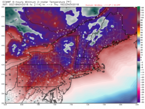
An arctic front will cross our area late Wednesday and usher in by far the coldest air of the season, record challenging in many cases. Low temperatures Wednesday night will bottom out at about 10°! Thanksgiving Day will be among the coldest ever seen in this area, with high temperatures struggling to get out of the teens, possibly reaching the low 20s to our south and east. Thursday night temperatures will sink to near 0° in the normally colder areas and to about 10° in the “warmer” urban areas. A slow moderation will begin Friday, as temperatures will recover to near 30° during the afternoon. Check out the low temperatures expected by the European model from the WeatherBell Analytics site which is attached.
The second potentially major event will approach our area late Saturday. A storm is expected to form along the southeast coast and move to the north northeast towards us. There is really little to say beyond this as the storm is days away from even forming and the track is completely uncertain at this point. However, in an early cold pattern like we are in, should the storm intensify and move northward off the coast, there is the chance of a major snowstorm, but it is equally possible that its track yields a rainstorm for us. It is definitely something to keep an eye on.
James M. Arnold was a Weather Specialist working with Shrewsbury Emergency Management Agency; town of Princeton; Worcester Emergency Communications and Emergency Management Agency; Southborough Emergency Management Agency; town of Grafton and Wachusett Mountain Ski Area


