


Submitted by Norman Corbin, Northborough Historical Commission
Photo/submitted
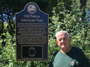
Northborough – Did you know there was an important Native American trail that crossed through Northborough? A new historic marker has been installed to commemorate its history and location.
Well before any European colonization of North America, the native population had many trails that acted as routes to food sources and neighboring tribal nations. Some of the major trails can be considered as their form of a super highway.
A significant trail passed through lands that are now part of Northborough. It was a loop trail that separated from what the Europeans called the Connecticut Path in Sudbury and reconnected with it in Grafton. The Connecticut Path was the major trail connecting the Massachusetts Bay with the Connecticut River; it travelled south of Northborough.
After starting in Sudbury, the loop trail travelled into Marlborough. It roughly proceeded from the current center of Marlborough along the southern shore of Lake Williams then to the base of Rock Hill in Northborough. This section would not be very different from travelling along Route 20 west to Williams Street then Forrest Street in Marlborough to Bartlett Street in Northborough. Just as it entered Northborough, it would have continued southwest over Rock Hill onto the old Westborough State Hospital property. Rock Hill is where there is a new warehouse building, along with the FedEx and A. Duie Pyle, Inc., distribution centers. The trail continued southwest leaving Northborough between Little Chauncy and Chauncy ponds into Westborough and then toward Grafton.
One key attribute of this trail is that it connected the native settlements in Marlborough to the one in Grafton.
The Marlborough natives were part of the Pennacook Federation of tribes that inhabited the valleys of the Merrimac and Connecticut rivers in Vermont, New Hampshire, and northern Massachusetts. They were closely related with the village of Wamesit which was located where the Concord River emptied into the Merrimack in the current city of Lowell. The Marlborough location was called “Okommakamesit” and their planting field was very near current downtown Marlborough.
In 1643 they petitioned and were granted land by the General Court in Boston well before the first European settlers were granted Marlborough land in 1656.
Grafton was the royal seat of the Nipmuc Nation. Their territory included central Massachusetts and adjacent portions of Connecticut and Rhode Island along the rivers and streams connected to the Blackstone, Quaboag, Nashua and Quinebaug rivers. It is estimated that there were 5,000 to 6,000 Nipmucs when the Pilgrims landed at Plymouth in 1620.
Today, the Nipmuc Tribe is a “state-acknowledged” tribe and very active in the community. Their reservation land in Grafton is called Hassanamesit and was granted in 1728. The current chief is Sachem Cheryll Toney Holley.
Both settlements were converted to “Praying Towns” between 1650 and 1675 by Rev. John Eliot of Roxbury. One can easily imagine Reverend Elliot traversing this trail as he taught the natives Christian values. During King Philip’s War between the colonists and natives (1675 to 1678) this trail became an important route.
The new marker is located on the Wachusett Aqueduct Trail just south of where it crosses Bartlett Street near the Marlborough line.
The Northborough Historic District Commission would like to express their gratitude to TA Realty for purchasing the sign and MWRA for installing it on their right-of-way.
For additional information:
- Nipmuc Nation Website: www.nipmucnation.org
- “The Great Trail of New England” by Harral Ayres, Meador Publishing, 1940


