


REGION – It won’t be the blizzard that dumped close to 18 inches of snow across the region this past weekend.
But forecasters say an approaching winter storm is still expected to cause problems Friday morning, bringing a mix of snow, sleet and ice throughout the morning.
“Plan on a slower than normal commute,” the National Weather Service’s Boston office wrote in a post to social media on Thursday. “Be aware that roads/walkways may become icy fast!”
Ice to mix with snow, sleet
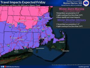
The NWS has shared graphics predicting between one and two inches of snow for area communities.
Of potentially greater concern, experts say, is the predicted ice accumulation from this event, which could total up to a quarter of an inch.
Effects will be most pronounced to the north of I-90, the NWS said in a previous social media post on Wednesday night.
“Plan accordingly,” they wrote.
NWS upgrades winter weather watch
The NWS upgraded a winter weather watch that had been posted for the region earlier this week to a winter weather advisory across area municipalities on Tuesday morning.
Even before that though, local emergency personnel were echoing forecasters’ warnings.
In Southborough, the fire department in particular advised residents to “be storm ready” on Wednesday night.
Conditions are expected to deteriorate overnight before impacts peak on Friday.
The NWS’ storm advisory, indeed, takes effect at 1 a.m. and will last through 7 p.m.
RELATED CONTENT
New snowfall measurements show impact of weekend nor’easter
Snow blankets region as major nor’easter arrives
Snow doesn’t stop Westborough touch football league


