


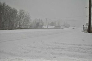
REGION – Yesterday’s winter storm dropped up to nine inches of snow on area communities, creating a messy end to the work-week for commuters and prompting warnings from state and local officials.
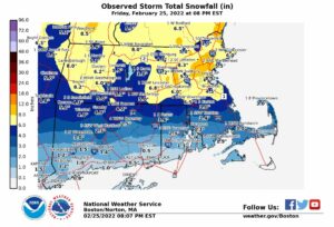
The National Weather Service released unofficial snow totals after snow wound down, showing Hudson leading area communities in accumulation, with nine inches of snow measured at 3:45 p.m.
Westborough’s highest reading maxed out at 8.5 inches while Grafton followed close behind with 8.1.
Shrewsbury saw eight inches as of 4:53 p.m.
Northborough’s snow, meanwhile, was measured at 7.4 inches at 4 p.m.
The snow started early, hitting the region with what meteorologists described in a forecast on Thursday as a “thump” of heavy precipitation on Friday morning.
State officials noted at least two crashes during some of the most intense hours of the storm, including a tractor trailer crash on I-495 in Marlborough.
A separate accident in Northborough briefly slowed traffic on I-290, though no one was injured according to State Police.
All this followed record warmth just hours earlier as nature offered an early taste of spring this past week before then roaring back with another reminder of winter.
Temperatures are now forecast to remain somewhat steady for much of the next week as the region slowly thaws out.
RELATED CONTENT
State officials report crashes on area highways as snow slows travel
Snow prompts closures, cancellations
Winter storm warning to take effect ahead of Friday snow


