


SHREWSBURY – Shrewsbury is targeting a single plot of 173 acres along Route 20 for MBTA zoning.
During the Planning Board meeting on March 7, Director of Planning and Economic Development Christopher McGoldrick outlined the town’s plan to comply with MBTA zoning. He also took questions from audience members about the proposed zoning efforts.
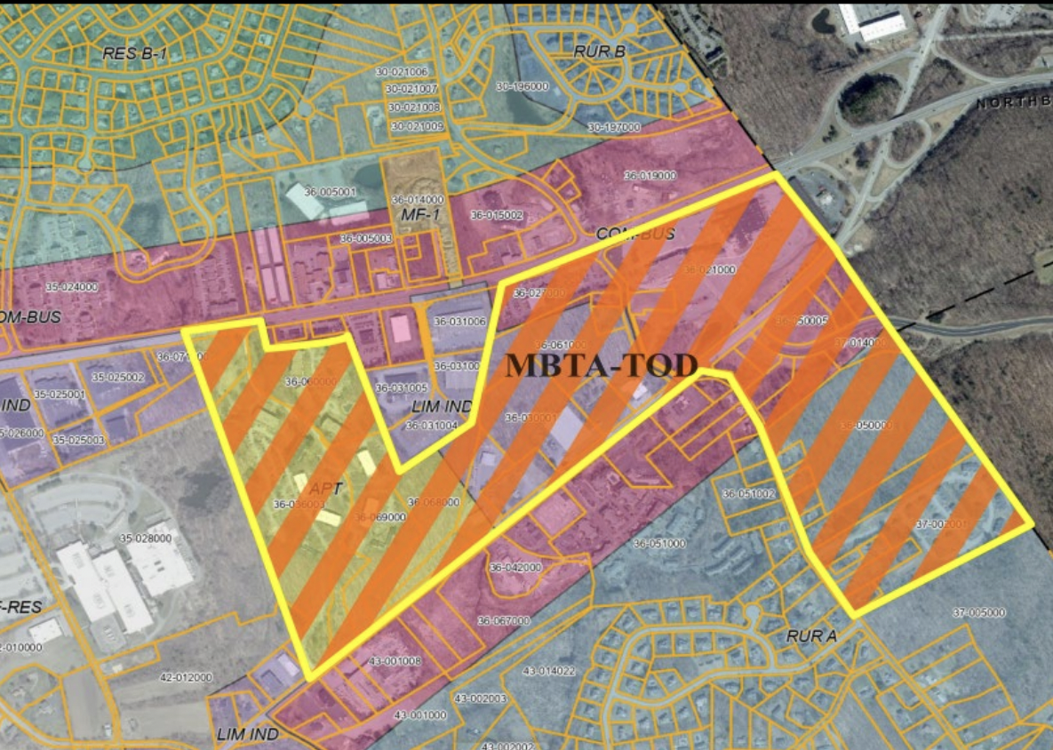
The proposed zone is located in the far southeast corner of Shrewsbury, near the intersection of Route 20 and Route 9. The zone includes Olde Shrewsbury Village – the site of the former Christmas Tree Shops location – and several other properties, including Shrewsbury Commons and the Sajda Drive development off Walnut Street south of Route 20. The site of the former Rainbow Motel is also included in the draft plans.
MBTA zoning explained
In an attempt to address the state’s housing crisis, Governor Charlie Baker signed the MBTA Communities Act in 2021. The law requires 177 towns with — or adjacent to — MBTA service to pass multifamily zoning. As an MBTA “adjacent community,” Shrewsbury must rezone to permit roughly 1,500 housing units, which is equal to 10% of the town’s current housing stock.
Shrewsbury does not need to build the units, but must zone an area to reasonably accommodate them.
Communities that do not comply with MBTA zoning break the law and lose eligibility for certain grants, which would amount to roughly $5 million for Shrewsbury. Many of the grants, as Town Manager Kevin Mizikar pointed out during the March 12 Select Board meeting, are currently used and often lead to opportunities for the town in the future. The actual impact would amount to more than $5 million in the future, he said.
The deadline to comply with the law is the end of 2024. Shrewsbury hopes to approve the MBTA zoning during the annual Town Meeting in May.
While the current proposal includes 173 acres of land, MBTA zoning requires only 50 acres. Shrewsbury is proposing to increase the amount of land in the zone in an attempt to balance the density of any potential development. In other words, the increased MBTA zoning acreage will lead to lower housing density and less potential for high-rise buildings in any future redevelopment of the area.
According to McGoldrick, Shrewsbury had sent out several surveys to town residents to gather suggestions for the zoning, and community members were split on what they valued more: acreage or density. One thing most residents agreed on, according to the presentation, was that they preferred “redevelop[ing] abandoned, vacant, or underutilized buildings and building lots.” The proposed zoning includes several now-defunct businesses, like the Rainbow Motel.
Shrewsbury identified six possible sites for MBTA zoning, including several sites along the Route 9 corridor close to Lakeway Commons, but the town settled on this Route 20-based proposal.
At the meeting, McGoldrick said that the proximity to the Westborough MBTA station was one of the main benefits of the site. The location is also close to Northborough’s proposed MBTA district.
Developers would be able to build up to 15 units per acre by right. However, McGoldrick said the proposed zoning bylaw contains several provisions to give the town input in the development process. There are several studies — including a local and regional transit analysis — that the town requires, and the town used “extensive” and strict language in design guidelines to give Shrewsbury a measure of control over any potential development.
“That’s one opportunity that we saw… We’ve really driven a lot of language there to allow local control of any project that’s developed on this [zoning],” McGoldrick said on March 7.
The town would mandate a mixed-use development if the underlying zone is commercial or industrial, which, according to language in the MBTA Communities Act, would make Shrewsbury eligible for a 25% offset and drop the number of required units to roughly 1,100. The zoning “formula” does not take into account existing multi-family units, and with several units seemingly within Shrewsbury’s zoning proposal, the 1,100 number could dip further.
Vertical mixed-use — similar to the proposed Beal Commons with commercial on the ground floor and housing above — would be allowed by right. Horizontal mixed-use — akin to Lakeway Commons, with commercial and residential in separate buildings — would require a special permit from the local government.
The proposed zoning also has benefits because it is one cohesive site, according to McGoldrick.
“It does provide one location that meets the requirements and provides that kind of cohesion. It’s also one of the least impactful in that way. By having one site, the number of net units is lower than combining some of the other districts that were proposed. It really provides that ability to meet that ‘minimum effective compliance,’ ” he said on March 12.
On the topic, Mizikar pointed to how it can often be difficult to upsize infrastructure in multiple locations at once. The single-site zoning would isolate the infrastructure improvements needed for any potential future development. Mizikar said that “there is a true efficiency gained on a single site versus spreading it out through the community.”
At the Planning Board meeting, residents voiced concerns that the zoning would add to an already-busy roadway. With Edgemere Crossing, the construction of the new Physik Instrumente headquarters, The Pointe at Hills Farm and 300 units possibly added along Green Street, Route 20 has seen an increased load of traffic and limited improvements. Some residents said they wait five minutes to turn onto Hartford Turnpike.
Residents are encouraged to share their opinion with local government. For more information on the town’s MBTA zoning efforts, visit https://shrewsburyma.gov/1408/ATM-2024-Zoning-Proposals.


