


By James M. Arnold, Weather Specialist
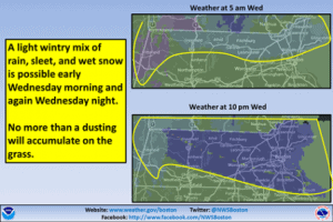 Region –Yes, we may see a wintry mix across parts of the area early Wednesday morning and again Wednesday night, as colder air is drawn into southern New England. The best chance of seeing (gasp) snow is across northern Massachusetts, where some locations could see a dusting of accumulation on the grass. The good news: The upcoming weekend looks sunny and mild!
It appears that our pattern flip towards a more seasonal and warmer regime is beginning and that next week will see temperatures at least at average values if not a bit higher for mid-April. We may see temporary relapses, but they should be relatively short lived as spring progresses. From this vantage point it looks like the Red Sox home opener next Monday could have ideal weather conditions with sunny skies and temperatures in the 60s.
James M. Arnold is a Weather Specialist working with Shrewsbury Emergency Management Agency; town of Princeton; Worcester Emergency Communications and Emergency Management Agency; Southborough Emergency Management Agency; town of Grafton and Wachusett Mountain Ski Area


