


By James M. Arnold, Weather Specialist
Region – It is quite a rare event when we see two powerful storms within 3 days of each other, but that is exactly what we are looking at.? A storm system is about to move off the Carolina coast and it will undergo “Bombogenesis” as it moves up the coast toward southern New England this afternoon and tonight.? Cloud to ground lightning strikes have been detected off the Delmarva peninsula this morning, an indication of the explosive?intensification taking place.? The National Weather Service has converted their Blizzard Watch for eastern Massachusetts to a Blizzard Warning, and expanded the Winter Storm Watch westward to include much of our area as well.
While there may be some occasional light snow in some areas this morning, the main event will begin early this afternoon. Snow will overspread our area about 1 to 2 P.M. and gradually become steadier and heavier by around 4 to 5 P.M.??This is a fast moving storm, and snow will be ending from west to east around midnight and the early morning hours of Sunday.? I am expecting a general area of from 6 to 10 inches from the Shrewsbury/Worcester area east and south, with amounts increasing nearer to the coast.? To our north, amounts will be a bit less, and?it looks like the bullseye for this storm will be the southern part of the South Shore, where up to 18 inches can be expected.? In spite of a heavy snowfall, the main story for this storm? will be the wind.? Winds will increase from the north and northeast during the afternoon and evening, reaching sustained speeds of 35 to 45 mph over the Cape and Islands with gusts?perhaps reaching 75 mph as the storm passes our latitude, around midnight.?? Inland?areas will not see that much wind, but central Massachusetts will see winds of 15 to 25 mph gusting to 40 mph later in the evening.? With heavy snow falling, whiteout conditions are quite likely, and there will be considerable blowing and drifting of the snow.??Travel across most of Massachusetts will be treacherous.??I do not expect any power outages in our area.
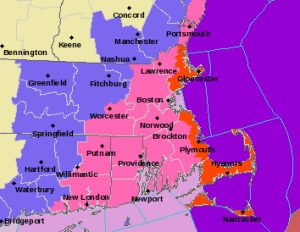
In coastal areas, Cape Cod and the Islands it could be a different story, as winds will be?much stronger and there is the likelihood of power outages as high winds?will likely?take down trees and branches laden with heavy snow.? Coastal flooding could become a minor?issue for north and northeast facing areas and beach erosion will likely be significant as coastal areas are pounded by large and battering waves.? Offshore, waves could reach nearly 30 feet with conditions becoming hazardous for the maritime community.
Sunday will dawn partly cloudy, breezy and cold, with temperatures in the 30s.
James M. Arnold is a Weather Specialist working with Shrewsbury Emergency Management Agency; town of Princeton; Worcester Emergency Communications and Emergency Management Agency; Southborough Emergency Management Agency; town of Grafton and Wachusett Mountain Ski Area


