


Photo/courtesy Carol Chione
Region – Strong wind gusts are wreaking havoc in the region causing, trees, branches and wires to come down.
In Southborough, a huge tree fell early this afternoon right near the Southborough Public Library sign, according to Ryan Donovan, the library’s director. He said that no one in the library heard it fall, but Kim Ivers, the children’s librarian, happened to go outside and saw the downed tree. When Donovan called the police he could hear sirens, so they were already on the way. Donovan said that the branch hit a car, and he was sure that the windshield was damaged. He said the DPW was quick to cut the section of the tree that had fallen onto Route 85. No one was injured.
The Shrewsbury Fire Department reported that trees fell on power lines on Dean Park. Crews there worked throughout the afternoon to contain the damage.
And as Weather Specialist James Arnold says in report below, the next few days will have a mix of about everything possible.
As Mark Twain said, “if you don’t like the weather in New England, just wait a minute.” The next five days will bring us about as many types of weather conditions as can be seen in months here in central Massachusetts. Fasten your seatbelts, because this is going to be a wild ride, and certainly one for the books if you are a weather enthusiast.
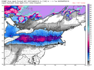
Today will feature partly cloudy skies and warm temperatures, with temperatures approaching the 70° mark this afternoon, with clouds increasing. It will also become very windy, with southwest winds of 20 to 30 mph occasionally gusting to 55+ mph during the afternoon. Showers and thunderstorms will move into our area later tonight and continue tomorrow. The strong winds of today will diminish and temperatures will remain on the mild side Friday. More showers and the threat of thunderstorms will be our lot Saturday ahead of and along a strong arctic front that crashes through the area later Saturday afternoon or at night. Winds will again increase from the northwest to 20 to 30 mph with gusts to 45 mph late Saturday night and into Sunday. Showers will likely become mixed with or change to snow Sunday before ending around noon. There could be some heavier snow squalls Sunday morning as well. Temperatures will fall to mid February levels, dropping to and remaining in the 30s for the rest of the day. Monday will see a disturbance approach southern New England bringing the threat of a significant early April snowfall.
I have attached model outlooks for the next few days with their current snowfall and temperature estimations. Check them out as they are pretty interesting. As we get closer to the possible snowstorm event for late Monday and Tuesday I will prepare an update.
James M. Arnold is a Weather Specialist working with Shrewsbury Emergency Management Agency; town of Princeton; Worcester Emergency Communications and Emergency Management Agency; Southborough Emergency Management Agency; town of Grafton and Wachusett Mountain Ski Area

Photo/Jane Keller Gordon


Photo/Jane Keller Gordon
Photo/courtesy Shrewsbury Fire Department Facebook page
Photo/courtesy Shrewsbury Fire Department Facebook page
Photo/courtesy Carol Chione


