


 By James M. Arnold, Weather Specialist
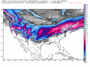
The Ground hog did indeed see his shadow and has forecast 6 more weeks of winter for us.? He surely must have seen the latest European model output as Joe D’Aleo suggested in his WeatherBell blog today.? That output appearing below (from the WeatherBell.com web site) shows a bullseye of snow over southern New England, eastern New York, central and eastern Pennsylvania and all of New Jersey, with amounts of 15 to 20 inches projected for these areas between now and February 12th.? While I am not one to give a lot of credibility to long range weather predictive models, there is a good chance this forecast will verify.
Our sensible weather is great today, a real taste of spring.? The high temperature today under partly cloudy skies?will reach into the 50s in many areas!? Tonight will be partly cloudy and cool, with low temperatures in the middle to upper 20s in most areas and tomorrow's light snowstorm for the south coast?will be mostly a non event in central Massachusetts, as any snow flurries are unlikely to make it any further to the north?than along the Mass Pike.? As that disturbance pulls away, skies will become partly cloudy and it will be cooler, with temperatures holding around 40 degrees.? Monday night will see temperatures fall to around 20 degrees with partly cloudy skies and Tuesday will dawn clear and cool.? That will soon change as clouds will be increasing from the southwest as storm number 3 in our series of four approaches.? You will hear about big snows around the Great Lakes and the western Ohio Valley, and that will be from our next storm, which will weaken in the Ohio River Valley.? It's energy will then transfer to the coast,?over or just off?the Delmarva peninsula and a new storm will form.? It should tap into a good moisture?feed?and?track off?to the northeast, passing over or just to the west of the benchmark.? This is?a prime track for considerable snow for southern New England.? Snow will likely begin late Tuesday night and continue into Wednesday afternoon.? Although it is still early to be thinking about numbers, this storm has the potential to bring central Massachusetts at least 4 to 8 inches of snow.? Amounts could be a little less south of the Mass Pike and a bit more in the higher ground to our north and west. Of course, track, temperature and where the heaviest banding sets up will determine how much snow any given area gets.? These details will be worked out as the event draws closer to us.
As the storm pulls away from us, the weather will turn pleasant again.? Partly cloudy conditions will prevail through early Friday, with high temperatures in the 30s and low?overnight temperatures around 20 degrees.? Friday will see increasing clouds and cold?as the forth in the series of 4 storms approaches.? Snow will likely begin Friday night or early Saturday and continue much of Saturday, ending during the evening.? This one is a long way out, but does hold good potential to be a fairly hefty snowfall for us.? Temperatures?should be colder than those of recent days and right now there appears to be little chance of rain getting into the picture.? This storm too, will track towards the benchmark, a track that?often leaves a deep snow cover over southern New England.??It is way too early to talk numbers so far in the future, but the odds favor more rather than less snow from this event.? And there may even be a fifth storm to become part of this parade, and that one would be followed by another surge of arctic air, as very cold temperatures seem poised to return to the northeast.
James M. Arnold is a Weather Specialist working with Shrewsbury Emergency Management Agency; town of Princeton; Worcester Emergency Communications and Emergency Management Agency; Southborough Emergency Management Agency; town of Grafton and Wachusett Mountain Ski Area


")

")