


By James M. Arnold, Weather Specialist
 Winter is just not ready to go away this year. We will see moderating conditions today, with highs reaching about 45° here in Shrewsbury, as long as we see a little bit of sun. Clouds will thicken later this afternoon and tonight with rain moving in around midnight, possibly mixed with a little snow at the onset. Tomorrow will be wet, windy and warmer. Rain will continue throughout the day and tomorrow night with the chance of a rumble of thunder during the late afternoon and evening. Friday morning will see the rain come to an end, but clearing will be slow to develop. After a partly cloudy start to the day Saturday, clouds will again thicken and rain will re-develop during the late afternoon and continue into Saturday night.
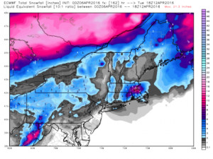
Here is where it gets tricky. An additional surge of pretty cold air will move into southern New England threatening to change the rain to snow over much of inland Massachusetts, Rhode Island and Connecticut. Should this happen, we could be looking at a general 3 to 6 inch accumulation overnight Saturday. Sunday will feature clearing and cool, breezy conditions. More rain will follow during the early portion of next week. Attached is a model outlook graphic for the potential snowfall Saturday night from the Joe D’Aleo blog of 4/6/16 at WeatherBELL.com.
By the way, the low temperature at my home this morning was 13°! That is exceptionally cold for April.
James M. Arnold is a Weather Specialist working with Shrewsbury Emergency Management Agency; town of Princeton; Worcester Emergency Communications and Emergency Management Agency; Southborough Emergency Management Agency; town of Grafton and Wachusett Mountain Ski Area


