


By James M. Arnold, Weather Specialist
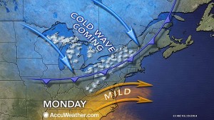 We can look forward to at least a two week period of wild weather here in most of southern New England.? The graphic below from AccuWeather.com shows the approaching arctic front which may be preceded by some brief but heavy snow squalls in central Massachusetts later this afternoon.? Very cold air will be driven by strong northwest winds, reaching 20 to 30 mph at times with some gusts to 40 mph late this afternoon and this evening.? Temperatures will fall from near 40 during the early afternoon to the 20s by early tonight and into the single numbers by Tuesday morning, setting the stage for the next snowstorm.
Clouds will increase towards tomorrow morning, slowly thickening and lowering during the day with snow beginning during the mid-to late- afternoon.? It will be very cold with temperatures in the low to mid-teens and winds will increase out of the north and northeast reaching 10 to 20 mph by early evening.? Snow will become steadier and heavier during the evening and continue throughout much of the night with continued very cold conditions, as temperatures could fall to the single numbers and the winds will continue to be in the 10 to 20 mph range with possible gusts to 30 mph.? Right now I am thinking we will see about 4 to 6 inches of very dry, powdery snow, and there will be considerable blowing and drifting, potentially creating temporary whiteout conditions.
The worst of the storm will be along the coast, the Cape and Islands, where up to a foot of wind driven snow is possible on the outer Cape and winds there could gust to 50 mph at the height of the storm.? This storm may pose a threat to mariners as seas could build to 15 feet and there will be the possibility of freezing spray due as a result of the very cold temperatures in place.? It does not appear that there will be any power outages as the snow along the coast, while possibly beginning as wet sticky snow, should quickly transition to more powdery snow and not stick to trees and power lines.
As usual, storm track is the crucial variable.? This system looks to be taking a track a bit more to the north at this time and if this trend continues all areas will see a more important snowfall, with blizzard conditions possible on the outer Cape and the Islands for a time at the height of the storm.? This is the first round in a series of events we will experience during at least the next two weeks, with several chances for snow (mostly light, but one could be significant) and temperatures struggling to reach average values for late January.? The next shot of true arctic air will be in about a week, and it could be even colder than that which is arriving this evening.
James M. Arnold is a Weather Specialist working with Shrewsbury Emergency Management Agency; town of Princeton; Worcester Emergency Communications and Emergency Management Agency; Southborough Emergency Management Agency; town of Grafton and Wachusett Mountain Ski Area


