By James M. Arnold, Weather Specialist
Region – Here is an update as of Sunday afternoon, Nov. 23, regarding a possible Thanksgiving Eve snowstorm:
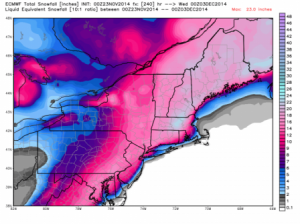
The European model shows a large swath of from 12 to 20 inches of snow headed our way. While I’m not sure I would agree with those amounts, I am becoming more concerned that much of our area could see a general 6 to 12 inch snowfall from late in the day Wednesday into Thursday. The storm should be taking shape off the South Carolina coast by late Monday and will move to a position near the Virginia Capes by Tuesday and move to the northeast on Wednesday arriving in New England during the late morning or early afternoon, likely beginning as a wintry mix but soon transitioning to all snow from west to east by evening on Wednesday. The first areas to go to all snow will be the higher ground to the north and west of Shrewsbury, and these areas will receive the most snow from this event. The last to transition will be the area adjacent to the Route 495 corridor and areas to the south of the Mass Pike, where the smaller final accumulations are expected.
Snow will continue Wednesday night becoming moderate to heavy at times and continue into Thursday morning before tapering off and ending before noon. Once again we are at the mercy of thermal profiles, what the exact storm track is and whether or not a coastal front sets up and where. With marginal temperatures for snow, it should be of the wet and heavy type.
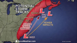
AccuWeather has captured what I think the likely track will turn out to be, and that is the one depicted in red, closer to the coast. I am anticipating the storm center to pass over or just to the west of the “Benchmark”, a track that favors a heavy snowfall for southern New England. As the storm intensifies, winds will increase from the northeast later Wednesday afternoon and night bringing the risk of tree damage and resultant scattered power outages into play. Tree limbs that become laden with a significant layer of wet, heavy snow will become susceptible to damage with the addition of increasing wind, and it is also possible that entire trees could come down as well. Most inland areas will likely experience winds of 15 to 25 mph with gusts of 35 to 40 mph by late Wednesday night. Thursday will see precipitation come to an end but the day will remain partly to mostly cloudy and cold, with high temperatures struggling to reach 40 in most areas. It will also be breezy from the northwest as the storm pulls away from us.
James M. Arnold is a Weather Specialist working with Shrewsbury Emergency Management Agency; town of Princeton; Worcester Emergency Communications and Emergency Management Agency; Southborough Emergency Management Agency; town of Grafton and Wachusett Mountain Ski Area


